Summer 2020 | eWavelengths
 Earning Its Wings: Woman-owned firm lands big survey contracts in N.C.
The Charlotte Douglas International Airport (CLT) in North Carolina is the 10th busiest passenger airport in the United States, ranking it higher than Orlando and Houston. In 2018, 46.4 million domestic travelers and 3.2 million international passengers moved through its 114 gates and five concourses. To help serve this exponential growth, CLT launched Destination CLT, a roughly $3.1 billion programko to renovate its concourses and expand its roadways, curb front, airfield and terminal. Duncan-Parnell's customer, CES Group Engineers, has been combining Trimble's modern survey instruments and scanning technology to provide first-class data to help build CLT's final destination.
CES Group Engineers, a certified women-owned small business has earned a place on some of the highest profile projects in the region in a notably short amount of time. Having built considerable success in environmental consulting for ten years, CES sought to diversify in 2011 and began providing professional land surveying services, a shrinking industry in North Carolina in recent years. They turned to Duncan-Parnell to not only help them choose the best tools to make their mark in land surveying, they capitalized on Duncan-Parnell's training expertise, consulting services and technical support to strengthen and grow their new surveying business division. Within a few years, CES was securing survey contracts approaching $1 Million.
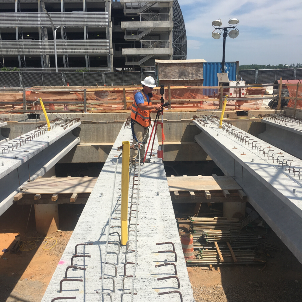
Destination CLT is one such project. Given CES's proven performance on previous design and construction surveying projects at the airport, multiple CLT prime contractors chose the company as the primary survey provider for more than 24 individual projects. One of those was the South-Crossfield Taxiway (SCT), a massive project that's building a new 4,000-foot-long taxiway to connect the central and east side of the airfield.
CES field crews needed to create a 30 topographic survey of a 300-acre site with varied terrain and infrastructure, as well as locate critical utilities, taxiways, runways and ramps to an accuracy of 0.01 feet.
Within the SCT, there was a 40-acre, concrete cargo apron, comprised of 107, 20 ft X 20 ft concrete slabs laid in a grid pattern. CES was required to pinpoint every concrete joint within this vast area, along with any grade change over the cargo space and taxiways.
To acquire that kind of survey detail, CES Geomatics Division Manager, Kent Hudson, PLS, calculated that it would require crews to take between 5,000 and 7,000 shots with traditional total stations. And they'd be in the field for eight nights. Hudson believed the Trimble SXl O Scanning Total Station, acquired from Duncan-Parnell, would be a better alternative.
Tackling The Tarmac
In January 2019, crews began the survey. Because the SCT is located within CLT's airfield, CES needed to perform their work overnight to avoid disrupting airport operations and for safety.
To meet the accuracies and deadlines required, CES surveyors arrived at the field with multiple Trimble technologies, including R8s GNSS receivers, S7 total stations and a DiNi digital level, all of which had been purchased from Duncan-Parnell.
They first set control using R8s GNSS receivers, occupying each control point multiple times and calculating the averaged coordinates for each point. They then ran a closed traverse loop using the S7 for horizontal control and the DiNi digital level for vertical control to within 0.01 ft. With control established, three different survey crews used multiple Trimble S7 total stations to collect all the field data including ground shots, utilities and critical tie-in points.
Hudson and a colleague scanned the cargo area, arriving on site one night at 11 :00 p.m. They used the previously established primary control network and set additional "spur" control points as needed. Setting the SXl O on a chosen control point, Hudson captured the scene, collecting not only the concrete joints and surface elevation variations, but also the tops and bottoms of retaining walls, storm grates and building corners at distances up to 300 feet from the instrument. In 1 0 scanning set ups, his crew captured the entire 40 acres in a single seven-hour shift.
"I went to the site expecting it would be a three-night job, and I was shocked that we got it all in one night," said Hudson. "Our dealer, Duncan-Parnell, had assured me that darkness wouldn't be a problem, and they were right. I not only acquired millions of 3D points that clearly show all the concrete seams and subtle grade variations, I captured substantially more data in just 13 percent of the originally-planned time." Back in the office, Hudson processed the point cloud using Trimble Business Center software and removed any extraneous features such as parked airplanes. He then created a 3D topographic model of the 40-acre concrete apron and exported it into AutoCAD to produce a final 3D surface. Two days after capturing the data, CES delivered the topographic survey to their client.
Being an integral part of such a high profile project is testament to how far CES has grown from the residential lot surveys it was providing only eight years ago. Duncan-Parnell is honored to have played a supporting role in CES's success, and as a trusted partner, it is committed to continuing to help CES secure the right technology at the right time.
Duncan-Parnell completes acquisition of GPServ (Florida)
Great news: Now a full year after acquiring GPServ in January 2019, the Florida geospatial dealer will now officially transition under the Duncan-Parnell brand. The Orlando-based Trimble distributor has provided a wide range of survey and mapping solutions for Sunshine State surveyors and GIS clients along with being a reliable partner among its customers for over 20 years.
"At Duncan-Parnell, we strive to create lifelong relationships built on value. So, I look forward to creating even stronger relationships with surveyors in the state of Florida and being there to continue and expand upon the support and solutions that GPServ has provided for the past 20 years." - Mark Duncan, President, Duncan-Parnell
It's an honor to enter into the state of Florida, and we look forward to continuing those efforts to make our customers' experience and business better than ever. We're overjoyed that the same familiar faces you've come to know at GPServ and their vast years of geospatial experience will be a part of the Duncan-Parnell family. We are thrilled to have the opportunity to serve our Florida customers and strengthen the resources and solutions for all surveying and mapping needs.
What you need to know about SiteVision
Trimble SiteVision is a user-friendly outdoor augmented reality system that brings data to life so you can visualize and explore complex information with unrivaled accuracy. Capabilities such as visualizing in 3D, measuring positions, collaborating in real time with easy-to-understand visualizations and reporting data to team members. SiteVision can advance any industry you're in such as Architecture, Building Construction, Utilities, Urban Transportation/Planning and more! Let's break down the specs:
• Integrated cm-accuracy GNSS with Trimble Catalyst
• Integrated Electronic Distance Measurement (EDM)
• Flexible design fits most phones (up to 8" screens)
• Waterproof and rugged
• Works hand-held or pole-mounted
Click here to view the full issue.